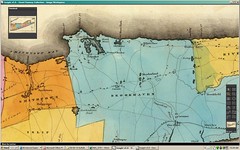
Old maps can sometimes reveal patterns in the landscape that will otherwise be missed. Case in point: Lake Ronkonkoma/Sachem. While exploring the headwaters of the Connetquot River, I discovered Islandia and Lakeside, lovely communities that have been able to retaining their 'country' character during Long Island's rapid suburbanization. Here, not far from the final stretches of the the historic Long Island Motor Parkway, you will find several horse farms and extensive bridal and hiking paths, as well as working farms and roadside farmstands. Part of the reason that this region has been overlooked can be identified on this image from an 1829 atlas. Lake Ronkonkoma served to mark the boundary between the Towns of Smithtown, Islip and Brookhaven. Portions of the region to the east were inundated by the damming of the Connetquot River and a larger territory was set aside as a greenbelt. Here in the heart of Long Island one finds a diversity of ecology and landscape that otherwise one would expect to find much further east. Watch this space for further notes and reports from the Lake Ronkonkoma region.