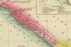
Finley map liberian coast 1831
Originally uploaded by Edu-Tourist.
Since returning from Jamaica my travels have been a little bit closer to home. In my spare time (or when I need a distraction, I like to hunt down historic maps on the Internet. This image is taken from an atlas for school use produced by a Philadelphia cartographer in 1831. It is so interesting to read the place names that the American colonists gave to the Liberian coast. Many of them, including the city of Philadelphia, exist to this very day. Too few Americans realize our historic ties to this region, and I have only had a chance to learn more about them since I have become a faculty member at Temple University in Philadelphia, PA. Think of the emphasis in different American schools in the early 1830s - the stories that teachers would be able to tell (if they chose to) about revolution in Haiti and colonization in Liberia. We would do well to remember these historic ties and the lessons they (should have) taught us during this current period of expanded American imperialism.

No comments:
Post a Comment