"Where on Long Island" - link - is one of my favorite flickr groups. Always welcoming new sharpsters to post and guess!
Friday, April 06, 2012
Saturday, February 18, 2012
Reimaginging the City
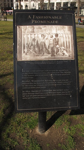
There are many cities besides the one that visitors glimpse through the lens of the guided tour. Old American cities like Philadelphia repay multiple visits and an openness to serendipity. On my quick visit yesterday I had time to kill before visiting with a potential masters student for a lunchtime chat. Following my geographical instincts, I happened upon Washington Square, renowned for its role as a publishing mecca - on the east side once can admire the ornate facade of J. B. Lippincott. Today there is much discussion of regreening the city as a strategy to fight climate change. Part of the solution is reimagining parks like Washington Square can be found in their history - perhaps we can find direction for the future cacooned in our collective past?
Sign reads:
"In the 17th century, when the Square first appeared in the city plan, streams drained into a deep gully in front of you. Then, beginning in 1833, geometric paths invited visitors into a leveled square planted with hundreds of trees.
"By 1846, Washington Square, with its seats, lamps and ornamental fences, had dramatically changed from the “offensive nuisance” of the 18th century into “a beautiful and fashionable promenade” where adults strolled and children played marbles.
"In 1853, American landscape architect Andrew Jackson Dowling’s Rural Essays praised Washington Square, reporting that it had 'more well grown specimens of different species of forest trees than any similar space of ground in America'."
Sunday, November 06, 2011
Stony Brook U.: sustainable living?
I'm looking forward to learning more about green initiatives on the Stony Brook University campus. Perhaps it is because I work in the bowels of the Health Sciences Center, but it takes a lot for information to filter down to me. The website is helpful but wish there was an event were I could get some of my questions answered - like whose roof garden was that I stumbled upon over the summer?
Friday, September 30, 2011
Memories of Edinburgh
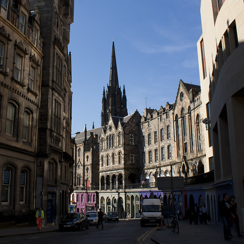
This image took me back fourteen years to my first days in Edinburgh. If I remember correctly, all of the new exchange students were delivered by bus to their various residences throughout the city. After getting settled at Rankin House, I took the few days before classes began to explore my local environment. The neighborhood around Edinburgh Castle was one of my favorite haunts. I enjoyed this view down Victoria Street several times a week, and even today I occasionally return to Edinburgh in my dreams.
Reconstruction of the Fables

The times that are a'changin:
1. Resignation of Temple University President Ann Weaver Hart, moving to Utah to care for her ailing mother.
2. Resignation of Stony Brook Medical Center Chief Executive Dr. Steven Strongwater.
3. News of the official breakup of classic 80s college radio band R.E.M.
Via Flickr:
This is the original Columbia Bicycle advertisement that was adopted by the Athens, GA rock group R.E.M. in promotional materials for their Fables of the Reconstruction album and tour.
Tuesday, September 06, 2011
Coming to the street near you
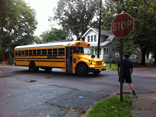
We are looking forward to quieter evenings now that the rambunctious youth of Port Jefferson Station are being redirected back to the life of the mind. We will see how long that lasts ;-)
Wednesday, August 31, 2011
Passaic River
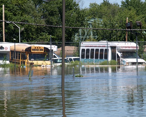
Hurricane Irene Aftermath: Submerged Jitney Buses in Paterson, New Jersey, a photo by jag9889 on Flickr.
In the summer of 1991 I worked for a week with a Habitat for Humanity affliate in Paterson, New Jersey. I was struck by the ethnic diversity of this post-industrial city and by the awesome natural setting of the falls that gave birth America's first planned industrial development.
Unfortunately the Passaic River flows out of the most rugged mountains in the state, and in the case of Hurricane Irene can cause tremendous destruction to lives and property. Check out jag 9889 for more of the shocking evidence.
Tuesday, August 30, 2011
reflections over an early morning cup of jo
Via Flickr:
Location: Bagels "N" a Hole Lot More
650 Patchogue Road, Port Jefferson Station, New York
This was our family's first major tropical storm. Carla, my wife, has been on service at the Stony Brook Medical Center all week. She came in early to help out with storm preparation.
And now that the storm has moved through we are dealing with some of the impacts of shifted activity patterns. Carla expects to see influx of patients to the hospital over the next week or so - folks who stayed away during the hurricane are now coming into Emergency with a wide variety of complaints and challenges.
Our neighborhood was largely spared - we live in Port Jefferson Station where the power went out early (5:00 am) but the few trees and limbs that went down were quickly removed. At this point it is anyone's guess how long it is going to take for LIPA to get a handle on things.
I went out to Bagels "N" A Hole Lot More in Port Jefferson Station for breakfast (excellent as always) and was treated to some pathetic stories of crossed lines of authority snarling response to downed wires in Stony Brook. Finally, this DOT employee had to turn to an emergency response team that had come up from Louisiana to take care of things. We of course could use more assistance of this sort, but communities upstate and in New England are facing much more dire circumstances.
Saturday, August 27, 2011
Visitor from the Tropics

Hurricane Irene Viewed From Google Earth Weather Satellite (8-27-11), a photo by 54StorminWillyGJ54 on Flickr.
Last year Carla and I visited Jamaica's Southeast Coast over the U.S. Labor Day Weekend. We were lucky to make it down to celebrate out 10th anniversary in a country we have grown to love, since Air Jamaica canceled the flight we were originally booked on. Earl turned out to be a disappointment last year. Long Island Power Authority laid out millions of dollars stationing advance teams for cleanup, but the storm dissipated before reaching New York.
This year we have another visitor from the tropics. Carla and I will be on the ground - Carla working at Stony Brook University Medical Center and Mike acting as an amateur videographer. Follow the latest news on our flickr stream.
image note:
Category 1 Hurricane Irene off the East Coast as of Saturday, August 27, 2011 at around 3:15 p.m.
Image via Google Earth Weather Satellite.
Tuesday, August 16, 2011
Litter Free Philadelphia Campaign
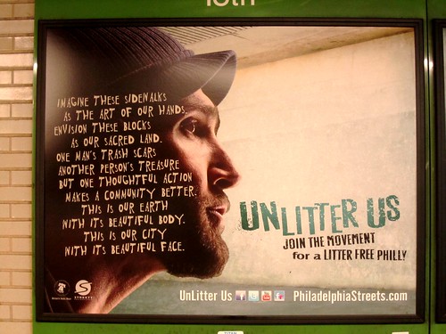
imagine these sidewals as the art of our hands
envision these blocks as our sacred land.
one man's trash scars another person's treasure
but one thoughtful action makes a community better
this is our Earth with its beautiful body
this is our city with its beautiful face
Via Flickr:
Thoughtful campaign to present a cleaner, litter free environment for visitors to Philadelphia. These shots were taken at the SEPTA trolley station near City Hall.
Friday, August 12, 2011
Reconnecting to place
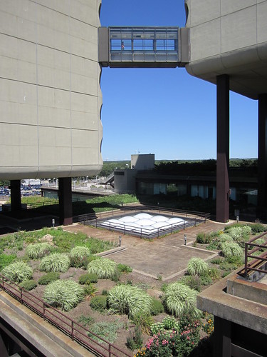
Working at Stony Brook University's Health Sciences Center is both a joy and a challenge. My office is a windowless bunker in the bowels of the complex, but only a few steps away one finds this wonderful expanse of roof terrace gardens. Unfortulately, few of hospital employees take responsibility for these exterior spaces. Their experience is more abstract - what we need to promote is an ethos of appreciation as well as a variety of practices of care. One small example that could be built upon is the small garden I discovered (visible from this same location if you were to rotate 180 degrees). I would love to know who started this garden and to what purpose its produce is directed.
Sunday, August 07, 2011
Advertisement for Bluepoints Company, Inc.
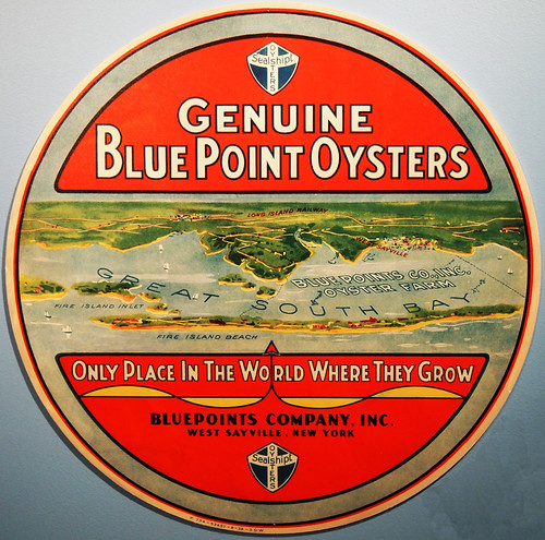
Though originally named for Blue Point, Long Island, where this oyster is said to have been first found, "bluepoint oyster" is now used as a general term referring to any of many small Atlantic oysters from 2 to 4 inches long. They are considered the best for eating on the half shell.
Read more: http://www.answers.com/topic/bluepoint-oyster#ixzz1UMQFVB2d
Saturday, April 09, 2011
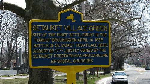
New Historical Marker for Setauket Village Green
If the cars speeding down Main Steet can slow down long enough, they will learn that the Setauket Village Green was site of first settlement in the Town of Brookhaven (April 15, 1655) and was involved in the Battle of Setauket (August 22, 1777). Setauket Presbyterian Church and Caroline Episcopal Church jointly own and maintain the green. Last October, the Historic Preservation Committee of Setauket Presbyterian Church held a very successful commemoration of the 350 years of worship in Setauket which in 1660 was the largest settlement in the Town of Brookhaven. One of the rebels to fight in the Battle of Setauket, Nathaniel Green, came back to the village after the war to find it in a sorry "state of wretchedness." He rallied local residents to rebuild the church, renovate the cemetery and recreate a sense of community amongst a people whose nerves had been frayed through years of military occupation and, for many, exile across the Long Island Sound in Connecticut. The church was razed by fire several times during Rev. Nathaniel Green's tenure. The current church structure was dedicated in 1812, so the Historic Preservation Committee is now planning to "rededicate" the church on its 200th birthday! Watch this photostream for updates.
I still have many of the photographs that were take at that church's 350 Celebration and have to decide how to make use of them. One idea is to create a video - much longer than the one that appeared on Three Village Patch yet building on the effortless way that it shares the storyline of the day.
I had the pleasure of meeting Ira Costell at today's meeting of the SPC Historic Preservation Committee. Mr. Costell filled us in in on the history of the Long Island North Shore Heritage Area [LINSHA] and the current initiative to commemorate George Washington's Culper Spy Ring with driving tour signs and audio description. This sounds like a wonderful idea, and I am wondering if there might not be ways for photographers with interest in historic landscapes and historic preservation to help out. Assuming that Session (comprised of SPC church elders) approves, we will soon see another historic marker on the green that connects to audio description of the role that the church and its members played to support the Revolutionary War effort.
Saturday, April 02, 2011
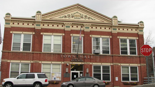
Town Hall - Town of Highlands, New York
Via Flickr:
I returned to Highland Falls to contest the ticket I received during my fall visit shortly after taking these photographs: Palisades Parkway; Death Head.
Thursday, March 31, 2011
Long Island Greenbelt Trail at State Route 111
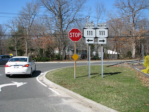
Long Island Greenbelt Trail at State Route 111, a photo by Edu-Tourist on Flickr.
Via Flickr:
This photograph was taken during a hike led by Shari on the central portion of the Long Island Greenbelt Trail. The hike on Marsh 19, 2011 was sponsored by the Long Island Greenbelt Trail Conference, a group of volunteers across Long Island who enjoy outdoor activities and look after an extensive trail network.This past month I have been enjoying many different opportunities to explore the island. As suggested by this post to Three Village Patch, activities organized by local hiking and biking clubs can, with a little bit of advance planning, become photowalks, where folks not only share their impressions during the event, but continue the conversation on social networking platforms like flickr, twitter or facebook. To learn more, join the Long Island Photowalk group on flickr - link - and join us for one of our monthly events!
Sunday, October 31, 2010
Field Report: Soldiers & Sailors Preserve from the Edison Tower
Note: This post is compiled from the Eco-Tour guide provided by Walter Stochel as well as personal observations - information on upcoming tours (.pdf)
The State of New Jersey owns 102 acres of parkland/preserves in the Menlo Park section of Edison. The parcels are located in the Southern Branch of the Rahway River watershed. When combined with the County owned Roosevelt Park, and an Edison Township parcel, there are 344 acres in this watershed that are preserved.
Our tour, led by Walter Stochel and Kyle, a local scout, began at the Edison Memorial Tower - photo - at the corner of Christie Street and Tower Road. This 131' tall monument was built at the exact location of Thomas Edison's Menlo Park Laboratory. Unmarked for many years, the Tower is now on the National Register of Historic Places and features a number of descriptive markers - 1 + 2. The tower will be undergoing restoration next year and the museum reopened after the removal of asbestos insulation. The undeveloped land you see around here is the 36-acre Edison State Park.
The tour began with some discussion of the significance of the Edison Tower - image. We then walked down Tower Road, which was originally called Woodbridge Avenue, to Frederick Street. Some of the houses we passed on the left were State owned (and rented). Following the path down to the ball field, recently cleaned up as part of a Boy Scout Eagle project, and through the woods to the west, we spied Carmen's Pond - photo & description. The Carmen family owned land in Menlo Park, and Wiliam Carmen was Edison's secretary. The pond is loaded with wildlife, ducks, geese, turtles, and fish.
Forming into a tight group, we scrambled through brush along the edge of Rt. 27 (the historic Lincoln Highway) to a new crosswalk, installed in response to local advocacy. Kyle pushed the button and the light changed so that we could cross the busy highway unmolested. Proceeding down the sidewalk, we soon arrived at a recently-improved and repainted underpass. Here the group stopped and listened to the story of how 50 Cub Scouts frustrated a succession of graffiti artists to reclaim this space. As you can see from the inset photo, the rusticated surface was very attractive with the shiny new coat of reddish brown paint.
Heading further south, we again stopped to view the forest on the west side of North Evergreen Road. These woods sit on a rugged 17-acre parcel that at one time was offered to developers but instead was bought by the State of New Jersey and Edison Township to be included in the Soldiers and Sailors Preserve. It is now managed by the New Jersey Natural Lands Trust. This is a mostly wooded upland tract, now a protected wetland.
Crossing over the South Branch of the Rahway River, we entered a large wooded parcel to the left. the 49-acre main parcel of the Soldiers and Sailors Preserve. Small streams and ditches cross this property. Isolated without parking access, it has been used over the years for children't play and shelter for homeless people. In the 1980s, the State of New Jersey entered a contract to sell this parcel to a developer who wanted to build a 26-story hotel/office/parking complex on the site. In the 200s, the sale was canceled and the property was transfered to the NJ Natural Lands Trust for preservation.
There are no marked trails in this preserve. We walked east through the site, and then south towards the railroad, until, after spotting the skeleton head of a deer, we finally ended up at a wide ditch. This was the end of our trail, and we retraced our steps. Taking a different route to the road, we ran across an old rusted children's toy that may have dated back to the 1950s and several trees that showed evidence of damage from rutting deer - image.
All in all, it was an excellent two-hour adventure into a rugged and natural bit of New Jersey. It is hard to believe that such beauty survives in the middle of the most extensively urbanized state in the country. These tours are held year-round:
More information on these hikes can be found on the Township of Edison website - flier.
Under Amtrak NE Corridor
uploaded by Edu-Tourist
The State of New Jersey owns 102 acres of parkland/preserves in the Menlo Park section of Edison. The parcels are located in the Southern Branch of the Rahway River watershed. When combined with the County owned Roosevelt Park, and an Edison Township parcel, there are 344 acres in this watershed that are preserved.
Our tour, led by Walter Stochel and Kyle, a local scout, began at the Edison Memorial Tower - photo - at the corner of Christie Street and Tower Road. This 131' tall monument was built at the exact location of Thomas Edison's Menlo Park Laboratory. Unmarked for many years, the Tower is now on the National Register of Historic Places and features a number of descriptive markers - 1 + 2. The tower will be undergoing restoration next year and the museum reopened after the removal of asbestos insulation. The undeveloped land you see around here is the 36-acre Edison State Park.
The tour began with some discussion of the significance of the Edison Tower - image. We then walked down Tower Road, which was originally called Woodbridge Avenue, to Frederick Street. Some of the houses we passed on the left were State owned (and rented). Following the path down to the ball field, recently cleaned up as part of a Boy Scout Eagle project, and through the woods to the west, we spied Carmen's Pond - photo & description. The Carmen family owned land in Menlo Park, and Wiliam Carmen was Edison's secretary. The pond is loaded with wildlife, ducks, geese, turtles, and fish.
Forming into a tight group, we scrambled through brush along the edge of Rt. 27 (the historic Lincoln Highway) to a new crosswalk, installed in response to local advocacy. Kyle pushed the button and the light changed so that we could cross the busy highway unmolested. Proceeding down the sidewalk, we soon arrived at a recently-improved and repainted underpass. Here the group stopped and listened to the story of how 50 Cub Scouts frustrated a succession of graffiti artists to reclaim this space. As you can see from the inset photo, the rusticated surface was very attractive with the shiny new coat of reddish brown paint.
Heading further south, we again stopped to view the forest on the west side of North Evergreen Road. These woods sit on a rugged 17-acre parcel that at one time was offered to developers but instead was bought by the State of New Jersey and Edison Township to be included in the Soldiers and Sailors Preserve. It is now managed by the New Jersey Natural Lands Trust. This is a mostly wooded upland tract, now a protected wetland.
Crossing over the South Branch of the Rahway River, we entered a large wooded parcel to the left. the 49-acre main parcel of the Soldiers and Sailors Preserve. Small streams and ditches cross this property. Isolated without parking access, it has been used over the years for children't play and shelter for homeless people. In the 1980s, the State of New Jersey entered a contract to sell this parcel to a developer who wanted to build a 26-story hotel/office/parking complex on the site. In the 200s, the sale was canceled and the property was transfered to the NJ Natural Lands Trust for preservation.
There are no marked trails in this preserve. We walked east through the site, and then south towards the railroad, until, after spotting the skeleton head of a deer, we finally ended up at a wide ditch. This was the end of our trail, and we retraced our steps. Taking a different route to the road, we ran across an old rusted children's toy that may have dated back to the 1950s and several trees that showed evidence of damage from rutting deer - image.
All in all, it was an excellent two-hour adventure into a rugged and natural bit of New Jersey. It is hard to believe that such beauty survives in the middle of the most extensively urbanized state in the country. These tours are held year-round:
#6 Saturday, November 6, 2010, from 9:00 am - 12 noon
Annual Menlo
Park School Nature Trail Cleanup
Meet: Menlo Park School parking lot, on
Monroe Avenue and Edison
#7 Sunday, November 14, 2010, from 10:00 am - 12 noon
Stevens Preserve
from Petti Lane
150 acres of wood to walk in
Meet: End of Petti Lane, Edison
#8 Date and time to be announced
Annual Greenway Hike
#9 Sunday, November 28, 2010, from 10 am - 12 noon
Millbrook parcel on Mill Road
Hike beside the Mill Brook on a slate
ridge.
Meet: End of Mill Road off of Old Post Road, at the New Jersey
Turnpike
#10 Sunday, December 5, 2010, 10am
Oak Ridge Park, located in both Edison and Clark Township
Any easy hike on paved roads - includes Ash Swamp
Meet: Parking lot off Featherbed Lane, in Edison
More information on these hikes can be found on the Township of Edison website - flier.
Sunday, October 24, 2010
Field Report: Middle States geography meeting in West Point, New York
This past weekend, I had the distinct pleasure of attending the 2010 Annual Meeting of the Middle States Division, Association of American Geographers - website. This is always an interesting meeting, but this year it had the added attraction of being held at the historic Thayer Hotel, located on the grounds of the United States Military Academy at West Point, New York. Having already visited the Academy back in the August 1995 while conducting research for my PhD dissertation, I was anxious to return. My memories of the first visit are sketchy: I was only there for a day, and wasn't that awake, having spent the previous evening at a tent in Bear Mountain State Park. I am sure I enjoyed that first visit, discovering useful West Point materials that would make their way into my dissertation, but in hindsight this summer might also represent a fallow period for my creative energies. I now realize that my photography really helps train my mind and memory, but by this point in my life I had given up on 35mm photography and had yet to take advantage of the rapid advances in digital. I was excited to be returning to West Point, to rediscover a landscape that I once known well, from personal acquaintance as well as from descriptions that I had read in the letters of nineteenth century travelers.
I got a late start driving up to West Point - the conference at noon, but I didn't drive onto the Academy grounds until 5:30 pm. Some of the delay had to do with business I needed to attend to on Long Island. But another contributor to the delay was the panorama of fall colors on display as I drove up the Palisades Interstate Parkway. I stopped to pick up maps at the Bear Mountain State Park Visitor's Center, located in a widened portion of the Parkway median, and again at Fort Montgomery State Historic Site. With the limited amount to time at my disposal, I wasn't able to tour the museum - although I later learned that it definitely worth an hour or two on my next trip. Instead I took to the trails, walking up to the Bridge crossing Popolopen Creek [taking the shot to the right] and down to the water's edge, which offered additional photo opportunities - check out some of the shots that I have posted to my flickr photostream (search for West Point).
Once I had finally arrived and checked in to the Thayer Hotel, I met up with my companion for the weekend, Katherine Keirns, a graduate student in the Federated Department of History (Rutgers-Newark & New Jersey Institute of Technology) who also happens to be my sister-in-law. We enjoyed the dinner buffet and options for night life. What turned out to be the last game of the American League Champoionship Series was on - the crowd seemed to be equally split between Yankees fans and haters.
Saturday morning, I attended (and tweeted) sessions on the History and Geography of West Point, and Military Geography. Both sessions were interesting, although I was particularly engaged during the first, because of my interest in photographing the historic fortifications and architecture of the campus, and because Katherine presented her paper "The Brush is Mightier than the Sword: How Drawing Nature Saved West Point" in that session. All of the papers were excellent and really helped give the audience a sense for the changing historical role of this awesome location. I hope to be able to share more insights from this sessions in forthcoming posts.
Kenneth E. Foote, a professor of Geography at the University of Colorado who is currently serving as President of the Association of American Geographers, delived a well-received lunchtime keynote concerning efforts to support the professional development of young faculty in the field. This luncheon doubled as an awards banquet. We were suprised to hear that Katherine had not only been selected as a member of the Middle States Geography Bowl team (based on her performance in the Geography Bowl challenge the previous evening) with financial support to compete at the national AAG conference in Seattle 2011, but was also selected one of the student paper competition winners. We aren't sure yet whether we will be making the trip, and thus reporting from, Seattle, so you'll just have to watch this space and see!
In no hurry to leave, Katherine and I signed on for a bus tour. Our guide was a middle aged woman with blonde hair and large sunglasses who had obviously been giving tours for many years and liked to speak from personal experience. Since this was the two-hour tour, we were able to visit many of the standard sites including the Cadet Chapel and the "million dollar view" from Trophy Point. But we also visited the Academy Cemetery, where we had a chance to look inside the Old Cadet Chapel and to interview two young men - first-years or "plebes" - who appeared to be writing up notes on some of the more significant former cadets who were buried there. If you visit my photostream, you will see that the tour gave me a chance to refamiliarize myself with some of the more iconic sites, and served to point out locations, such as the monument to Tadeusz Kosciuszko, that I would return to on my own later. As you can see from my "All Things Kosciuzko" photoset I have a soft spot for the Polish engineer and freedom fighter who redesigned the defenses at West Point and who, in his will, set aside funds for Thomas Jefferson to use in freeing his slaves. As Gary Nash documents in the book Friends of Liberty he co-authored with Graham Hodges, Thomas Jefferson was never able to make good on his promise. Kosciuszko spent the year 1797-1798 convalescing in Philadelphia from disabilities occassioned fighting for human freedom from bondage in both Europe and the Americas (NPS). His vision would take generations for the country to fully (if ever) realize.
Wednesday, September 29, 2010
Field Report: 36th Annual Atlantic Antic Street Fair
It seems like all of Brooklyn turns out for the Atlantic Antic - link. The section of the Avenue from Atlantic Termal (Flatbush Avenue) to the water is turned over to venders and performances. It gets better every year - this is only the second time I've gone. I posted photographs of the day to my flickr photostream. Amongst the venders that caught my eye was this one selling New York Subway homage t-shirts. Almost bought one, but decided this photo would do almost as well. I did spring for another retro t-shirt: a 70s-flavor homage to bicycling in Brooklyn. Once I get a shot of it I'll try to post it here.
Sunday, August 29, 2010
Elegantly Simple

Eisenhower Interstate System in the style of H.C. Beck's London Underground Diagram
Originally uploaded by Senex Prime
Wednesday, August 18, 2010
Exploring Lake Ronkonkoma
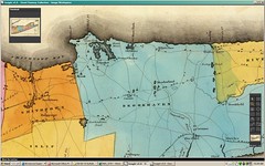
Towns of Smithtown & Brookhaven, from David Burr, An Atlas of the State of New York (1829)
Originally uploaded by Edu-Tourist
Subscribe to:
Posts (Atom)
