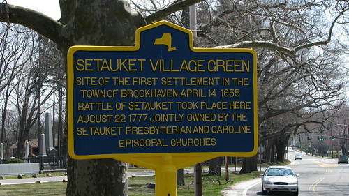
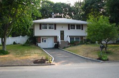
If the cars speeding down Main Steet can slow down long enough, they will learn that the Setauket Village Green was site of first settlement in the Town of Brookhaven (April 15, 1655) and was involved in the Battle of Setauket (August 22, 1777). Setauket Presbyterian Church and Caroline Episcopal Church jointly own and maintain the green. Last October, the Historic Preservation Committee of Setauket Presbyterian Church held a very successful commemoration of the 350 years of worship in Setauket which in 1660 was the largest settlement in the Town of Brookhaven. One of the rebels to fight in the Battle of Setauket, Nathaniel Green, came back to the village after the war to find it in a sorry "state of wretchedness." He rallied local residents to rebuild the church, renovate the cemetery and recreate a sense of community amongst a people whose nerves had been frayed through years of military occupation and, for many, exile across the Long Island Sound in Connecticut. The church was razed by fire several times during Rev. Nathaniel Green's tenure. The current church structure was dedicated in 1812, so the Historic Preservation Committee is now planning to "rededicate" the church on its 200th birthday! Watch this photostream for updates.
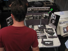
I still have many of the photographs that were take at that church's 350 Celebration and have to decide how to make use of them. One idea is to create a video - much longer than the one that appeared on Three Village Patch yet building on the effortless way that it shares the storyline of the day.
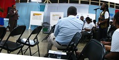
I had the pleasure of meeting Ira Costell at today's meeting of the SPC Historic Preservation Committee. Mr. Costell filled us in in on the history of the Long Island North Shore Heritage Area [LINSHA] and the current initiative to commemorate George Washington's Culper Spy Ring with driving tour signs and audio description. This sounds like a wonderful idea, and I am wondering if there might not be ways for photographers with interest in historic landscapes and historic preservation to help out. Assuming that Session (comprised of SPC church elders) approves, we will soon see another historic marker on the green that connects to audio description of the role that the church and its members played to support the Revolutionary War effort.
Saturday, April 09, 2011
New Historical Marker for Setauket Village Green
Saturday, April 02, 2011
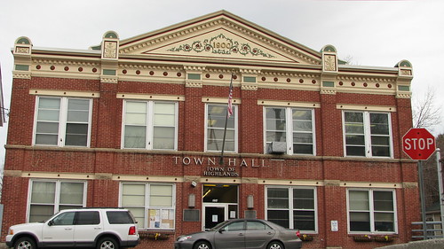
Town Hall - Town of Highlands, New York
Via Flickr:
I returned to Highland Falls to contest the ticket I received during my fall visit shortly after taking these photographs: Palisades Parkway; Death Head.
Thursday, March 31, 2011
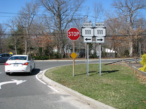
Long Island Greenbelt Trail at State Route 111
Via Flickr:
This photograph was taken during a hike led by Shari on the central portion of the Long Island Greenbelt Trail. The hike on Marsh 19, 2011 was sponsored by the Long Island Greenbelt Trail Conference, a group of volunteers across Long Island who enjoy outdoor activities and look after an extensive trail network.This past month I have been enjoying many different opportunities to explore the island. As suggested by this post to Three Village Patch, activities organized by local hiking and biking clubs can, with a little bit of advance planning, become photowalks, where folks not only share their impressions during the event, but continue the conversation on social networking platforms like flickr, twitter or facebook. To learn more, join the Long Island Photowalk group on flickr - link - and join us for one of our monthly events!
Sunday, October 31, 2010
Field Report: Soldiers & Sailors Preserve from the Edison Tower
Under Amtrak NE Corridor
uploaded by Edu-Tourist
The State of New Jersey owns 102 acres of parkland/preserves in the Menlo Park section of Edison. The parcels are located in the Southern Branch of the Rahway River watershed. When combined with the County owned Roosevelt Park, and an Edison Township parcel, there are 344 acres in this watershed that are preserved.
Our tour, led by Walter Stochel and Kyle, a local scout, began at the Edison Memorial Tower - photo - at the corner of Christie Street and Tower Road. This 131' tall monument was built at the exact location of Thomas Edison's Menlo Park Laboratory. Unmarked for many years, the Tower is now on the National Register of Historic Places and features a number of descriptive markers - 1 + 2. The tower will be undergoing restoration next year and the museum reopened after the removal of asbestos insulation. The undeveloped land you see around here is the 36-acre Edison State Park.
The tour began with some discussion of the significance of the Edison Tower - image. We then walked down Tower Road, which was originally called Woodbridge Avenue, to Frederick Street. Some of the houses we passed on the left were State owned (and rented). Following the path down to the ball field, recently cleaned up as part of a Boy Scout Eagle project, and through the woods to the west, we spied Carmen's Pond - photo & description. The Carmen family owned land in Menlo Park, and Wiliam Carmen was Edison's secretary. The pond is loaded with wildlife, ducks, geese, turtles, and fish.
Forming into a tight group, we scrambled through brush along the edge of Rt. 27 (the historic Lincoln Highway) to a new crosswalk, installed in response to local advocacy. Kyle pushed the button and the light changed so that we could cross the busy highway unmolested. Proceeding down the sidewalk, we soon arrived at a recently-improved and repainted underpass. Here the group stopped and listened to the story of how 50 Cub Scouts frustrated a succession of graffiti artists to reclaim this space. As you can see from the inset photo, the rusticated surface was very attractive with the shiny new coat of reddish brown paint.
Heading further south, we again stopped to view the forest on the west side of North Evergreen Road. These woods sit on a rugged 17-acre parcel that at one time was offered to developers but instead was bought by the State of New Jersey and Edison Township to be included in the Soldiers and Sailors Preserve. It is now managed by the New Jersey Natural Lands Trust. This is a mostly wooded upland tract, now a protected wetland.
Crossing over the South Branch of the Rahway River, we entered a large wooded parcel to the left. the 49-acre main parcel of the Soldiers and Sailors Preserve. Small streams and ditches cross this property. Isolated without parking access, it has been used over the years for children't play and shelter for homeless people. In the 1980s, the State of New Jersey entered a contract to sell this parcel to a developer who wanted to build a 26-story hotel/office/parking complex on the site. In the 200s, the sale was canceled and the property was transfered to the NJ Natural Lands Trust for preservation.
There are no marked trails in this preserve. We walked east through the site, and then south towards the railroad, until, after spotting the skeleton head of a deer, we finally ended up at a wide ditch. This was the end of our trail, and we retraced our steps. Taking a different route to the road, we ran across an old rusted children's toy that may have dated back to the 1950s and several trees that showed evidence of damage from rutting deer - image.
All in all, it was an excellent two-hour adventure into a rugged and natural bit of New Jersey. It is hard to believe that such beauty survives in the middle of the most extensively urbanized state in the country. These tours are held year-round:
#6 Saturday, November 6, 2010, from 9:00 am - 12 noon
Annual Menlo
Park School Nature Trail Cleanup
Meet: Menlo Park School parking lot, on
Monroe Avenue and Edison
#7 Sunday, November 14, 2010, from 10:00 am - 12 noon
Stevens Preserve
from Petti Lane
150 acres of wood to walk in
Meet: End of Petti Lane, Edison
#8 Date and time to be announced
Annual Greenway Hike
#9 Sunday, November 28, 2010, from 10 am - 12 noon
Millbrook parcel on Mill Road
Hike beside the Mill Brook on a slate
ridge.
Meet: End of Mill Road off of Old Post Road, at the New Jersey
Turnpike
#10 Sunday, December 5, 2010, 10am
Oak Ridge Park, located in both Edison and Clark Township
Any easy hike on paved roads - includes Ash Swamp
Meet: Parking lot off Featherbed Lane, in Edison
More information on these hikes can be found on the Township of Edison website - flier.
Sunday, October 24, 2010
Field Report: Middle States geography meeting in West Point, New York
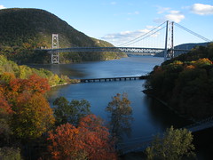
This past weekend, I had the distinct pleasure of attending the 2010 Annual Meeting of the Middle States Division, Association of American Geographers - website. This is always an interesting meeting, but this year it had the added attraction of being held at the historic Thayer Hotel, located on the grounds of the United States Military Academy at West Point, New York. Having already visited the Academy back in the August 1995 while conducting research for my PhD dissertation, I was anxious to return. My memories of the first visit are sketchy: I was only there for a day, and wasn't that awake, having spent the previous evening at a tent in Bear Mountain State Park. I am sure I enjoyed that first visit, discovering useful West Point materials that would make their way into my dissertation, but in hindsight this summer might also represent a fallow period for my creative energies. I now realize that my photography really helps train my mind and memory, but by this point in my life I had given up on 35mm photography and had yet to take advantage of the rapid advances in digital. I was excited to be returning to West Point, to rediscover a landscape that I once known well, from personal acquaintance as well as from descriptions that I had read in the letters of nineteenth century travelers.
I got a late start driving up to West Point - the conference at noon, but I didn't drive onto the Academy grounds until 5:30 pm. Some of the delay had to do with business I needed to attend to on Long Island. But another contributor to the delay was the panorama of fall colors on display as I drove up the Palisades Interstate Parkway. I stopped to pick up maps at the Bear Mountain State Park Visitor's Center, located in a widened portion of the Parkway median, and again at Fort Montgomery State Historic Site. With the limited amount to time at my disposal, I wasn't able to tour the museum - although I later learned that it definitely worth an hour or two on my next trip. Instead I took to the trails, walking up to the Bridge crossing Popolopen Creek [taking the shot to the right] and down to the water's edge, which offered additional photo opportunities - check out some of the shots that I have posted to my flickr photostream (search for West Point).
Once I had finally arrived and checked in to the Thayer Hotel, I met up with my companion for the weekend, Katherine Keirns, a graduate student in the Federated Department of History (Rutgers-Newark & New Jersey Institute of Technology) who also happens to be my sister-in-law. We enjoyed the dinner buffet and options for night life. What turned out to be the last game of the American League Champoionship Series was on - the crowd seemed to be equally split between Yankees fans and haters.
Saturday morning, I attended (and tweeted) sessions on the History and Geography of West Point, and Military Geography. Both sessions were interesting, although I was particularly engaged during the first, because of my interest in photographing the historic fortifications and architecture of the campus, and because Katherine presented her paper "The Brush is Mightier than the Sword: How Drawing Nature Saved West Point" in that session. All of the papers were excellent and really helped give the audience a sense for the changing historical role of this awesome location. I hope to be able to share more insights from this sessions in forthcoming posts.
Kenneth E. Foote, a professor of Geography at the University of Colorado who is currently serving as President of the Association of American Geographers, delived a well-received lunchtime keynote concerning efforts to support the professional development of young faculty in the field. This luncheon doubled as an awards banquet. We were suprised to hear that Katherine had not only been selected as a member of the Middle States Geography Bowl team (based on her performance in the Geography Bowl challenge the previous evening) with financial support to compete at the national AAG conference in Seattle 2011, but was also selected one of the student paper competition winners. We aren't sure yet whether we will be making the trip, and thus reporting from, Seattle, so you'll just have to watch this space and see!
In no hurry to leave, Katherine and I signed on for a bus tour. Our guide was a middle aged woman with blonde hair and large sunglasses who had obviously been giving tours for many years and liked to speak from personal experience. Since this was the two-hour tour, we were able to visit many of the standard sites including the Cadet Chapel and the "million dollar view" from Trophy Point. But we also visited the Academy Cemetery, where we had a chance to look inside the Old Cadet Chapel and to interview two young men - first-years or "plebes" - who appeared to be writing up notes on some of the more significant former cadets who were buried there. If you visit my photostream, you will see that the tour gave me a chance to refamiliarize myself with some of the more iconic sites, and served to point out locations, such as the monument to Tadeusz Kosciuszko, that I would return to on my own later. As you can see from my "All Things Kosciuzko" photoset I have a soft spot for the Polish engineer and freedom fighter who redesigned the defenses at West Point and who, in his will, set aside funds for Thomas Jefferson to use in freeing his slaves. As Gary Nash documents in the book Friends of Liberty he co-authored with Graham Hodges, Thomas Jefferson was never able to make good on his promise. Kosciuszko spent the year 1797-1798 convalescing in Philadelphia from disabilities occassioned fighting for human freedom from bondage in both Europe and the Americas (NPS). His vision would take generations for the country to fully (if ever) realize.
Wednesday, September 29, 2010
Field Report: 36th Annual Atlantic Antic Street Fair
Sunday, August 29, 2010
Elegantly Simple

Eisenhower Interstate System in the style of H.C. Beck's London Underground Diagram
Originally uploaded by Senex Prime
Wednesday, August 18, 2010
Exploring Lake Ronkonkoma
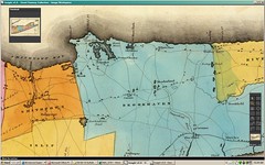
Towns of Smithtown & Brookhaven, from David Burr, An Atlas of the State of New York (1829)
Originally uploaded by Edu-Tourist
Monday, July 26, 2010
Distance and orientation
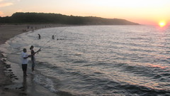
The David Weld Santuary looked perfect, but it was a little too far, on the other side of Smithtown. I had heard locals describe the distinctive cultural mix of Sunken Meadow Beach so I thought I would give it a shot, even though it seemed like it would be more east- than west-facing.
I parked in the largely empty parking lot and jogged down to the boardwalk, not knowing exactly what to expect. Certainly I did not expect that so many other visitors would be carring professional-looking fishing poles and gear. And the second surprise was seeing the sun preparing to set OVER WATER in the western sky!Where had my mental calculations gone wrong? And how many days do we left have to enjoy this spectacle?
Monday, July 12, 2010
Meandering through the Ohio Valley to the way to Missouri

Thursday, July 08, 2010
Long Island Seasoning
As our society is forced to find ways to live more simply, perhaps there are lessons to be learned by exploring the emergence of Long Island's suburban landscape. There are insights to be gleaned right in my immediate neighborhood, such as this simple residence on Ringtail Lane in East Setauket/Stony Brook. Houses in this style date from one of the first major waves of suburbanization on Long Island; many of them have been modified and improved over the years. This house, however, retains much of the original rustic summer camp feel, with the utilitarian first floor and the more expansive second floor to catch the summer breezes.
While the summer temperatures in my neighborhood are moderated by the proximity to Long Island Sound, the humidity is very high, and it is not uncommon to get one's summer reading unexpectedly drenched from an unscheduled downpour.
Sunday, July 04, 2010
Exploring Long Island's East End
This occasional blog is over five years old and this weekend Carla and I are celebrating our tenth anniversary. So nice to have a place to record the milestones in our lives. I don't have to feel self-conscious about how infrequent I post here, since blogs are yesterday's news: the pulse of innovation has moved on facebook and twitter.
Saturday, October 31, 2009
Welcome to Port Jefferson Station, NY
Thursday, September 17, 2009
Philadelphia streets may still be mean, but now are also GREEN
Philadelphia is undergoing a green makeover under the leadership of Mayor Nutter's new Office of Sustainability. Although employees of the City have been taking advantage of PhillyCarShare for several years, the Office of Sustainability is forging new partnerships - facebook. In this blog post, I would like to feature two new initiatives being advanced by our community's excellent universities.
Penn Current: the University of Pennsylvania unveiling its new Climate Action Plan Wednesday, detailing green practices and policies.
Temple News: Taking advantage of incentives to bike to campus, including additional bike racks and a new bicycle maintenance facility, Temple University students are reducing their carbon footprint. These are only a few of the campus-wide developments featured University's Office of Sustainability.
Tuesday, August 11, 2009
St. Thomas, 114 years ago

The National Library of Jamaica has recently joined the elite group of museums of are sharing some of their valued map collections with the general public. This is one of my favorites so far - a closeup of the parish of St. Thomas from a 1895 map of the island.
Getting a sense of the political landscape on Long Island
Sunday, March 15, 2009
The psychology of Caribbean people at home and abroad
Saturday, December 27, 2008
Travelogue
Saturday, July 05, 2008
Saying Goodbye
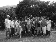

The great thing about photoexpeditions is that you not only get to look at your own photos years later, but you also get to share multiple interpretations of the same site. So it was the the Morant Point Lighthouse Trip - such an evident success that we are definely going to have to plan a followup for the return trip to Jamaica. After viewing my photographs (many taken on rainy days), several members of the Kingston, Jamaica Flickr Meetup Group have expressed their desire to hike the Cunha Cunha and/or Corn Puss Gap trails. As far as I know, the Cunha Cunha Trail is the only one open to the public, and this is only due to the carefuly management of the Bowden Pen Farmers, on behalf of eco-tourists, the national park and their fellow community residents. Corn Puss Gap, renowned amongst birders, would need a similar investment of effort in order to be cleared. Perhaps we have put the hurricane years in our past, and we can work together to publicize and reopen this national treasure. MD
Friday, July 04, 2008
Photo featured with NPR story
Meanwhile, other photos taken in Philadelphia have been getting the attention of the National Parks Conservation Association and National Public Radio. On July 1, NPR ran a story on the National Park System that featured a photograph, I took two years ago of the exterior of the Tadeusz Kosciuszko National Memorial, located at 2nd and Pine in the Society Hill neighborhood of Philadelphia. I thought it was a great capture at the time, and it is really fulfulling to find that others agree! The story of this national memorial is just fascinating to me, and was pleased to see how Robert Smith captured it in audio and text for NPR, even though the story apparently generated some critical listener feedback.
